


Remarkable NASA Satellite Image Exposes Thermal Radiation Escaping from Iceland’s Recent Fissures.
The volcanic fissures in Iceland, which have been active for centuries, have caused concern among the residents of Grindavik and captivated onlookers. Recently, lava from one of these fissures has engulfed several homes. However, the situation seems to be improving as seismic activity has decreased and hazard warnings have been downgraded, although they still remain high.
Despite these positive developments, Grindavik is still at risk of fault movements, lava flow, and the emergence of new fissures without any prior warning. This information was last updated by the Icelandic Met Office on January 19.Furthermore, recent satellite imagery from NASA indicates that significant amounts of heat are still being emitted from the fissures near Grindavik. These fissures had remained dormant for 800 years before this sudden volcanic activity occurred.
The map provided below illustrates the heat emanating from the fractured land surface, as detected by a thermal infrared sensor on NASA’s Landsat 9 satellite. Although the temperature scale is not specified, it showcases the extensive size of the fissures, which are filled with bubbling hot lava.
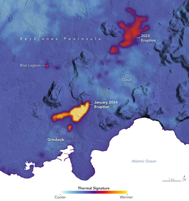
The map data was gathered on January 16, 2024, just two days following the alarming occurrence of two fissures near Grindavik on January 14.
Superimposed on a digital representation of the terrain, one can observe the initial fissure from January 14, which extended to an impressive length of approximately 900 meters as it was skillfully diverted using man-made barriers. Additionally, there is a smaller fissure that breached the outskirts of the town, and both of these fissures are emitting scorching streams of molten lava.
The magma intrusions beneath the surface and the subsequent earthquakes that led to the evacuation of Grindavik in January are not depicted on the map. This seismic information is gathered on-site and is currently under close observation by geologists.
The eruptions that occurred near Grindavik in December 2023 and January 2024 mark the fourth and fifth instances within a span of less than three years along the Reykjanes peninsula.
A previous image, generated last year using data obtained from the Landsat 9 satellite, showcases the lava flows originating from the Fagradalsfjall volcanic system northeast of Grindavik. These flows occurred in March 2021, August 2022, and July 2023, leaving the land charred black.
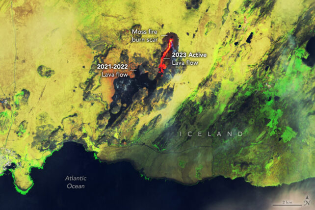
A photograph taken on 17 July 2023 by the Operational Land Imager-2 (OLI-2) instrument on Landsat 9 shows lava flows in false-color. This image, captured by Wanmei Liang of NASA Earth Observatory, provides a unique perspective on the volcanic activity.
Prior to the recent eruptions, the Reykjanes peninsula had remained inactive for a remarkable 800 years. However, between approximately 1210 and 1240, a series of eruptions occurred, lasting several decades. The town of Grindavik was established on top of the solidified lava flows from those past eruptions, making its residents familiar with volcanic events.
Iceland is renowned for its high level of volcanic activity, as it is situated on a mid-ocean ridge that is gradually separating. Additionally, a mantle plume rises from beneath, contributing to the volcanic phenomena.
Geologist Jaime Toro from West Virginia University explains that Iceland is divided by the tectonic plate boundary between the North American and Eurasian plates. This continental faultline bypasses the capital city of Reykjavik and directly crosses the Reykjanes peninsula, where Grindavik is located near its tip.
We hope that the volcanic activity beneath the Reykjanes peninsula has subsided for the time being. The Icelandic Met Office provides regular updates on the situation.
This article is republished from sciencealert under a Creative Commons license. Read the original article.
Do not forget to share your opinion with us to provide you with the best posts !


0 Comments